The inland hills between Canyon Lake and Riverside offer a diverse range of hiking environments, characterized by canyons, rolling ridgelines, lake overlooks, and restored open spaces. Those exploring Canyon Lake hiking trails or nearby routes in Riverside can expect clearly defined paths that highlight the region’s natural landscape. The area’s proximity to foothills, reservoirs, and protected habitat creates a strong foundation for year-round hiking.
Canyon Lake Overlook Trail: Views of the Reservoir and Surrounding Hills
The Canyon Lake Overlook Trail, situated near the eastern edge of the community, offers elevated viewpoints of the reservoir. The trail consists of a series of linked dirt paths that ascend gradually along low ridges. Hikers gain open sightlines toward the Main Lake, the surrounding neighborhoods, and the Santa Ana Mountains in the distance.
The terrain is primarily composed of compact soil with scattered rock formations. Its short length makes it accessible for quick outings, but the viewpoints provide a rewarding sense of elevation. Many residents use the trail as a consistent way to enjoy scenery close to home while avoiding longer drives to larger networks.
The terrain is primarily composed of compact soil with scattered rock formations. Its short length makes it accessible for quick outings, but the viewpoints provide a rewarding sense of elevation. Many residents use the trail as a consistent way to enjoy scenery close to home while avoiding longer drives to larger networks.
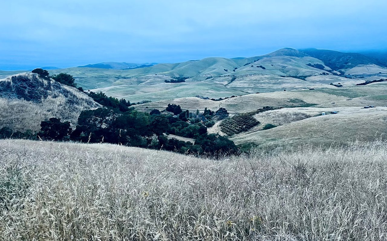
San Jacinto River Trail: A Corridor of Open Terrain
The San Jacinto River Trail follows a natural corridor that extends between Canyon Lake and the surrounding foothills. The route parallels portions of the seasonal riverbed and features dirt paths suitable for walking, biking, and equestrian activities. Vegetation remains sparse along most segments, providing hikers with clear views across the corridor.
During cooler months, the area’s open terrain provides wide, unobstructed hiking routes with gentle elevation changes. The trail system also functions as a connector for outdoor recreation in the region, allowing hikers to explore the river basin without navigating urban development.
During cooler months, the area’s open terrain provides wide, unobstructed hiking routes with gentle elevation changes. The trail system also functions as a connector for outdoor recreation in the region, allowing hikers to explore the river basin without navigating urban development.
Lake Elsinore Levee Walk: A Flat Route with Mountain Views
Located a short drive west of Canyon Lake, the Lake Elsinore Levee Walk includes a raised path that extends along parts of the shoreline. The levee gives users a broad perspective across the lake, with the Ortega Mountains framing the western edge and the Elsinore foothills rising toward the east.
The levee’s flat grade makes it ideal for those seeking a consistent pace and uninterrupted views. Portions of the route connect to nearby parks and small side trails, offering chances to explore additional shoreline access points.
The levee’s flat grade makes it ideal for those seeking a consistent pace and uninterrupted views. Portions of the route connect to nearby parks and small side trails, offering chances to explore additional shoreline access points.
Cleveland National Forest: Santa Ana Mountains Trailheads
The Cleveland National Forest lies west of Lake Elsinore and features trailheads that require a short drive from Canyon Lake. One of the most popular nearby trails is the San Juan Loop, located near the Ortega Highway. The loop travels through chaparral, oak-shaded pockets, and sections of exposed terrain with canyon views.
Another nearby hike, the Chiquito Trail, offers a longer, more rugged route with substantial elevation gain. These trails highlight the transition between the lowland foothills and the higher terrain that characterizes the Santa Ana Mountains.
Another nearby hike, the Chiquito Trail, offers a longer, more rugged route with substantial elevation gain. These trails highlight the transition between the lowland foothills and the higher terrain that characterizes the Santa Ana Mountains.
Sycamore Canyon Wilderness Park: Riverside’s Urban-Nature Blend
In Riverside, Sycamore Canyon Wilderness Park spans over a thousand acres of protected land, featuring a network of intersecting trails. The park sits adjacent to residential districts but maintains a strong natural identity through open hillsides, sycamore groves, and exposed granite formations.
Trails like the Canyon Crest Loop and the Alessandro Trail offer moderate climbs that reveal sweeping views of Riverside and the surrounding mountains. Sycamore Canyon attracts hikers who prefer an extensive trail system within a short distance of an urban center.
Trails like the Canyon Crest Loop and the Alessandro Trail offer moderate climbs that reveal sweeping views of Riverside and the surrounding mountains. Sycamore Canyon attracts hikers who prefer an extensive trail system within a short distance of an urban center.
Mount Rubidoux Trail: Riverside Landmark with a Paved Summit Route
Mount Rubidoux is one of Riverside’s most recognizable outdoor destinations. The paved trail spirals gradually around the mountain, leading to a summit marked by a stone tower and a prominent cross. The viewpoint offers a panoramic view of downtown Riverside, the Santa Ana River corridor, and the surrounding ridgelines.
While the path is paved, the steady ascent provides enough challenge to engage walkers and hikers seeking a structured climb. The trail’s historic markers and exposed rock features reinforce its local significance.
While the path is paved, the steady ascent provides enough challenge to engage walkers and hikers seeking a structured climb. The trail’s historic markers and exposed rock features reinforce its local significance.
Box Springs Mountain Reserve: A Network of High-Elevation Trails
Box Springs Mountain Reserve, situated between Riverside and Moreno Valley, features several challenging trails that ascend steep mountain slopes. The Two Trees Trail is one of the most well-known and climbs quickly to a ridge overlooking both cities.
The reserve’s other trails, including the Box Springs Summit Trail and the M Trail, provide additional routes to high viewpoints. Wildlife sightings, broad plateaus, and exposed rock faces characterize the experience. The reserve offers a contrasting environment to the more gentle Canyon Lake hiking trails, giving hikers a wide range of challenge levels.
The reserve’s other trails, including the Box Springs Summit Trail and the M Trail, provide additional routes to high viewpoints. Wildlife sightings, broad plateaus, and exposed rock faces characterize the experience. The reserve offers a contrasting environment to the more gentle Canyon Lake hiking trails, giving hikers a wide range of challenge levels.
Santa Rosa Plateau Ecological Reserve: Prairie, Oak Woodlands, and Vernal Pools
A short drive south leads to the Santa Rosa Plateau Ecological Reserve near Murrieta. Trails here pass through rolling grasslands, basalt outcroppings, and oak-studded woodlands. Paths such as the Granite Loop Trail and Vernal Pool Trail highlight the plateau’s distinct topography.
The broad prairies and quiet corridors give the reserve a different feel from canyon-centered hikes. The historic adobe ranch and information center help contextualize the landscape, while interconnected trails allow hikers to build routes of varying lengths. Its ecological diversity positions the reserve as a major hiking destination for inland Southern California.
The broad prairies and quiet corridors give the reserve a different feel from canyon-centered hikes. The historic adobe ranch and information center help contextualize the landscape, while interconnected trails allow hikers to build routes of varying lengths. Its ecological diversity positions the reserve as a major hiking destination for inland Southern California.
North Peak of Canyon Lake: Localized Ridge Walks
North Peak is situated along the northern boundary of the Canyon Lake community and features informal walking paths that are used by residents. These dirt routes follow ridgelines that offer views toward Quail Valley, Menifee, and the lake itself. The gradual climbs and open terrain provide uncomplicated access to elevated viewpoints.
While not an official trail system, the area remains a popular spot for localized exercise and short hikes. The ease of access and quiet environment distinguish it from more formal trail networks.
While not an official trail system, the area remains a popular spot for localized exercise and short hikes. The ease of access and quiet environment distinguish it from more formal trail networks.
Connect with Kreg McCoy
Kreg McCoy guides clients interested in neighborhoods that provide convenient access to Canyon Lake hiking trails and other outdoor amenities. His knowledge of the region helps buyers and sellers make informed decisions when pursuing real estate opportunities in this active inland community.
Interested in Canyon Lake real estate? Contact us today and we’ll be happy to help you find your dream Canyon Lake home!
Interested in Canyon Lake real estate? Contact us today and we’ll be happy to help you find your dream Canyon Lake home!
